Precision Aerial Surveys, Photography, and Videography Services
Maryland Aerial Intelligence Solutions
Baltimore Helicopter Charters delivers comprehensive aerial survey capabilities across Maryland, encompassing advanced applications such as magnetometer and electromagnetic surveys, LiDAR data acquisition, and precision GIS mapping. Our access to helicopters that excel in low-altitude flight and stable hover performance ensures the capture of highly accurate and detailed geospatial data, critical for diverse infrastructure and environmental projects. Furthermore, we facilitate specialized aerial cinematography and photography, utilizing sophisticated camera systems and offering aircraft configurations, including door-off options for handheld work, to meet stringent production requirements. We provide tailored aerial solutions for your Maryland-based data collection and visual documentation needs.

Aerial
Surveys
LiDAR, GIS Maps, FLIR, HD Video & More
Baltimore Helicopter Charters provides essential aerial support for critical infrastructure management, including detailed pipeline inspections, Right-of-Way (ROW) assessments, and routine transmission line patrols throughout Maryland. We ensure access to the precise rotorcraft and specialized sensor packages required to execute these projects accurately and efficiently, safeguarding your operational integrity.
High Tech Results
The Top Pilots in Maryland, Today's Technology... Maximum Results.
Call 410-276-3405 Now!
Baltimore Helicopter Charters provides the tools needed to complete your land surveys, utilizing the right equipment to provide the aerial photos that are often needed.
Executing an effective aerial survey streamlines critical operations such as Right-of-Way (ROW) and site inspections, precise topographical data acquisition, and high-definition aerial imaging for commercial development projects across Maryland. Helicopter-based surveys offer unparalleled access for detailed pipeline leak detection, comprehensive transmission line diagnostics, and precise property documentation. Baltimore Helicopter Charters specializes in designing bespoke photographic and remote sensing operations, meticulously customized to optimize technical specifications, enhance financial efficiency, and consistently deliver superior actionable results for your Baltimore-based projects.
Helicopters are uniquely suited for precision aerial surveying due to their distinct operational envelopes, which permit significantly lower flight altitudes and reduced airspeeds compared to fixed-wing aircraft. While the Federal Aviation Administration (FAA) mandates a minimum 1,000-foot altitude above obstacles for fixed-wing operations, helicopters can maneuver at much lower levels, providing superior detail and proximity for data acquisition. This inherent agility allows for meticulous inspection of challenging or hazardous zones within the Baltimore region, offering engineers and project managers an invaluable vantage point and data resolution often unattainable by other aerial platforms.
There is no better way to conduct your visual survey, animal population counts, soil drainage analysis, ROW inspections, pipeline and transmission line inspections, and geographical surveys.

LiDAR Imaging
Light Detection and Ranging, or LiDAR, is a remote sensing method used to examine and measure Maryland topography as well as objects, like vegetation, upon it.
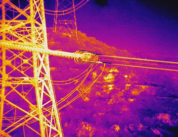
Infrared Imaging
Thermographic IR cameras are used to detect radiation in the long-infrared range of the electromagnetic spectrum and produce images of that radiation, called thermograms.
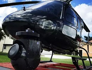
HD Video Gimbal Capture
Modern HD and 4K cameras can be mounted to helicopters, using the proper STCs, with a gimbal to stabilize photos & videos for detailed results.

Cutting-Edge Aerial Filming and Professional Cinematography
For expert camera work in the Baltimore Sky
Get a Fast, free QuoteBaltimore Aerial Cinematography
Baltimore Helicopter Charters facilitates unparalleled access to professional-grade aerial cinematography resources throughout Maryland, empowering your production team with advanced capabilities. We coordinate custom shoots utilizing industry-leading gyro-stabilized camera mounts, including Tyler Mounts, Wesscam, Cineflex, Pictorvision, and SpaceCam, integrated with high-performance specialty cameras such as Cineflex HD, RED Epic, and Arri Alexa, alongside cutting-edge 3D and experimental camera systems. Our comprehensive support extends to all production facets, from air-to-air and ground-to-air shots, ensuring precise execution of your visual objectives. Helicopter operations are conducted with a focus on seamless collaboration with aerial Directors of Photography and directors to achieve superior cinematographic results. Specializing in rotorcraft platforms for both still and motion photography, Baltimore Helicopter Charters provisions for a broad spectrum of media operations across Maryland, including feature films, television series, documentaries, impactful promotional videos, commercials, aerial props, rapid relief support for television networks, and extensive coverage of historical and major sporting events with a diverse fleet of helicopters.
Call Us Today at 410-276-3405 for a Free Quote
Contact Us
Aerial Photos
Hand-held or Mounted OpTions in Baltimore
We will help you get the right equipment for your aerial photography project! Call 410-276-3405 today to get a fast, free quote.
The Most Options for Photography
Maryland's diverse landscapes offer compelling subjects for professional aerial photography, with the optimal perspective achieved from a rotorcraft platform. Our aerial photography charter services are meticulously designed to enable the precise capture of your envisioned visuals, transforming conceptual frameworks into high-quality imagery. Baltimore Helicopter Charters provides strategic aerial solutions for photographic missions across the state, from the Chesapeake Bay to the Appalachian foothills. Many helicopters can be configured with doors removed for dynamic handheld projects, and we also offer sophisticated gyro-stabilized mounts to ensure maximum image stability and precision, crucial for demanding professional applications.
Superior Service
Every one of our customers gets a dedicated helicopter expert to assist with flight plans, tech loadouts, production logistics, project schedules, and other demands.
Over 500 Aircraft
Our network of direct air partners extends well beyond Baltimore, Maryland. This allows us to offer a wide range of solutions for even the most sophisticated projects.
The Best Equipment
From high-tech sensors like LiDAR, FLIR, and GIS to HD cameras and movie production gimbals, we're here to make your job as easy as possible.